Mid-Year Estimates 2016

The South Africa I know,

The Home I Understand

Results for: mid-year population estimates

Mid-Year Estimates 2016

Mid-Year Estimates 2016

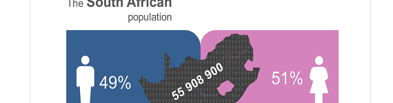
55,9 million people in South Africa:  Planning for a better tomorrow The population of South Africa is estimated to be 55, 9 million by end June 2016. Between 2002 and 2016 South Africa experienced a positive population growth year on year. Between 2002 and 2016, there was an overall increase in Life expectancy (55,2 to   read more »


Closing in on the 55 million mark: A growing population with changing needs.

Statistics South Africa (Stats SA) today released mid-year population estimates which put South Africa’s population at just over 54,9 million as at July 2015. The population increased by 1,65% between 2014 and 2015, with Gauteng remaining the most populous province, with almost 13,2 million inhabitants, followed by KwaZulu-Natal with a population of almost 10,9 million.   read more »


Media Release, Mid –Year Population Estimates 2014

Statistics South Africa (Stats SA) estimates the population of South Africa to be 54 million as at July 2014, where about 30,0% of the population is aged younger than 15 years and approximately 8,4% (4,54 million) is 60 years or older. The Mid-year population estimates further indicate that approximately fifty-one per cent (approximately 27,64 million)   read more »


Life expectancy continues to rise as South Africa’s population breaks 54 million

Life expectancy continues to rise as South Africa’s population breaks 54 million

South Africa’s population now stands at just over 54 million. This is the main finding of Stats SA’s latest Mid-year Population Estimates report, which was released on Thursday. Based on the 2014 series, the country’s population experienced an estimated net increase of 844 000 individuals (1,58% growth) from July 2013 to July 2014. Gauteng remains the   read more »


Stats SA releases new provincial GDP figures

Stats SA releases new provincial GDP figures

After a two-year hiatus, Stats SA has released an experimental set of provincial gross domestic product (GDP) data. Provincial-level figures used to be included annually with the GDP release. Following the publication of the 2019 data, the provincial series was temporarily held back as Stats SA embarked on a complete revamp of national accounts. This   read more »


GDP declines in the fourth quarter

GDP declines in the fourth quarter

After rallying in the third quarter of 2022, South African gross domestic product (GDP) declined by 1,3% in the fourth quarter (October‒December).1 Growth was dragged lower mainly by finance, trade, mining, agriculture, manufacturing and general government services. Finance and trade the biggest drags on growth Seven of the ten industries contracted in the fourth quarter.   read more »


Stats SA Media Communications

MEDIA ADVISORY                                                                                           11 November 2022       The global population is set to reach 8 billion on 15 November 2022. The Statistician-General of South Africa, Mr Risenga Maluleke, and the Representative for the United Nations Population Fund (UNFPA), Dr Bannet Ndyanabangi, will jointly commemorate the World at 8 Billion at a media briefing to   read more »


Economic, social and political empowerment are critical for achieving gender equality in SA

Economic, social and political empowerment are critical for achieving gender equality in SA

More than half (51,1%) of the South African population are female[1] and, according to the General Household Survey (GHS) 2021, more than two-fifths (42,0%) of households are headed by females. While women empowerment is central to the global development agenda and is a stepping stone to gender equality, a new report released by Statistics South   read more »


Mbalo Brief – August 2022

The Mid-year population estimates (MYPE) offer key indices and estimates regarding births, deaths and migratory movements in the country, as well as key estimates by age, sex and geographical data that assist in planning for and addressing the needs of the population. The upcoming Census 2022 results (to be published in 2023) will be a key source   read more »


60,6 million people in South Africa

60,6 million people in South Africa

The population of South Africa is estimated to be 60,6 million by the end of June 2022. Between 2002 and 2022 South Africa experienced a positive population growth year-on-year. A positive growth rate indicates that the population is increasing, despite the devastating impact of COVID-19 globally and within South Africa’s borders. By 2022, measures of   read more »


No publication results found.

Perhaps you should try again with a different search term.

Naledi

Naledi Local Municipality (NW392) covers a total area of approximately 7,258 km². This land mass is 15% of the total area of the Dr. Ruth S Mompati District Municipality area. The administrative centre of the municipality is in the town of Vryburg. The town of Vryburg is considered the agricultural and industrial centre of Dr Ruth S Mompati District Municipality. The town is the host to the 3rd largest agricultural show in South Africa, namely Vryburg Show, which attracts farmers from almost all provinces in the country as well as farmers from the neighbouring countries such as the Republic of Namibia and Botswana. This makes the municipality the main employer within the district and most significant contributor to GDP. Naledi Local Municipality is separated into five main places, namely, Vryburg town, Huhudi township, Colridge township, Stella, Devondale and Dithakwaneng village. The municipal area is surrounded by the other three local municipalities within the district, namely, Greater Taung Municipality (70km), Kagisano Molopo Municipality (70km) and Mamusa Municipality(70km). The town of Vryburg is about 140km away from Kuruman town in the Northern Cape Province and 160km from Mahikeng municipality, the administrative centre of the North West Province. The municipality is divided into 9 administrative wards and has a total of 18 ward councillors (ward councillors and their assistants/PR councillors).  read more »


Mamusa

Mamusa Local Municipality (NW393) covers a total area of approximately 3 681 km². This land mass is 7,8% of the total area of the Dr. Ruth S Mompati District Municipality. The administrative centre of the municipality is in the rural area of Schweizer-Reneke situated on the banks of the Harts River and at the foot of the Mamusa hills. The town of Schweizer-Reneke is the only town in Mamusa Local Municipality and is surrounded by agricultural farms. Schweizer-Reneke is the main administration centre for the local municipality and is closer to the township called Ipelegeng. Other townships under Mamusa Local Municipality include Amalia, Glodina, Migdol and Sharon. The Mamusa Local Municipality is situated about 70 km from Vryburg, where the district municipality offices reside.    read more »


Greater Taung

Greater Taung Local Municipality (NW 394) is situated in the western part of North West in the area of jurisdiction of Dr Ruth S Mompati District Municipality. The municipality is one of the five local municipalities in Dr Ruth S Mompati District Municipality.The municipality covers an area of 5 639 Km2, which accounts for 11,8 % of the total area of Dr Ruth S Mompati District Municipality.The main rural towns/townships in the municipal area are Reivilo, Pudimoe and Taung Central. About 95% of the municipal area is predominantly rural. There are about 106 widely-scattered villages in the municipal area. There are Northern Cape areas that one passes when going from one village to the other within the municipality, namely Pampierstad township and Northern Cape farms. These areas previously formed part of the municipality but were later moved to the Northern Cape during the last demarcation process. The municipality is divided into 26 administration wards and has a total of 52 councillors (both ward and PR councillors). As the municipality is predominantly rural, villages have been divided under the three tribal authorities under three paramount chiefs, namely Mankuroane, Mothibi and Motlhabane. The agricultural sector, both commercial and subsistence, is the major employer and contributor to the municipal economy. The municipal population stands at 177 642 (the largest in the district), with a total of 48 612 households.When compared to the 2001 population statistics, the population size has declined from a total of 182 164 to 177 642 in 2011. The average population density stands at 31,5km2.read more »


Lekwa-Teemane

Lekwa-Teemane Local Municipality (NW396) is approximately 3 681 km² in extent. This land mass makes up 7,75% of the total area of the Dr. Ruth S Mompati District Municipality area. The administrative centre of the municipality is in the rural area of Christiana. The other offices are located in Bloemhof. The major towns are Bloemhof and Christiana, which are predominantly farming towns, hence the major private-sector employers are farmers. Both of these towns can be described as rural to semi-rural and spreads. Apart from these two rural towns, most of the residents live in villages and townships. Christiana and Bloemhof are about 60 km away from each other. The Christiana area is composed of Christiana town, Geluksoord township, Christiana farms and the Utlwanang township, whereas the Bloemhof area is composed of Bloemhof town, Bloemhof farms and the Coverdale township, Salamat township and Boitumelong township.

With a total of 14 930 households, Lekwa-Teemane Local Municipality has the smallest population in the Dr RSM district. The average population density for Lekwa-Teemane Local Municipality has increased from 13,5 people per km2 in 2001 to 14,5 people per km2 in 2011. The municipality is divided into seven administration wards and has a total of 14 councillors (both ward councillors and PR councillors).

read more »


Kagisano Molopo

Kagisano Molopo Local Municipality (NW397), is approximately 23 827 km².The municipal name, Kagisano Molopo, emanates from two former local municipalities, namely Kagisano and Molopo, which were mergedon 18 May 2011 to form what is now known as Kagisano Molopo Local Municipality (KMLP). The local municipality is located at the north-western corner of the NorthWest province.It borders the Republic of Botswana to the north, Joe Morolong Local Municipality in the Northern Cape to the south-west,Naledi Local Municipality to the south-east, and Ratlou Local Municipality to the east. For the year 2013/14, the municipality runs at an estimated overall budget of R110 million (source: Kagisano Molopo IDP, 2012-2017). Kagisano Molopo Local Municipality is a 100% rural municipality which consists of 77 villages under the leadership of a single paramount chief. There are seven local chiefs who operate from seven areas/villages, namely Morokweng, Tlakgameng, Tseoge, Mmadinonyane, Phaposane, Mabane and Kgokgoje villages. The 77 villages are divided into 15 political wards with a total of 30 ward councillors. Kagisano Molopo is the second largest local municipality in terms of population size within Dr Ruth SegomotsiMompati District. As per Census 2011 results, the total population stood at 105 789, which constitutes 22,8% of the entire district’s population. The municipal population size increased from 100 469 in 2001 to 105 789 in 2011.read more »


No statistics by theme results found.

Perhaps you should try again with a different search term.