Mid-Year Estimates 2016

The South Africa I know,

The Home I Understand

Results for: northern cape

Mid-Year Estimates 2016

Mid-Year Estimates 2016

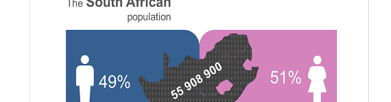
55,9 million people in South Africa:  Planning for a better tomorrow The population of South Africa is estimated to be 55, 9 million by end June 2016. Between 2002 and 2016 South Africa experienced a positive population growth year on year. Between 2002 and 2016, there was an overall increase in Life expectancy (55,2 to   read more »


Media Release: Free State Community Survey 2016 results

  Free State Community Survey 2016 results The total population recorded for Free State in 2016 was 2,8 million, an increase from the population of 2,7 million in 2011, making it the second smallest province in the country in terms of population size, after the Northern Cape.  58,3% of the population in the province are   read more »


Construction: what are the costs per square metre?

Construction: what are the costs per square metre?

Stats SA distinguishes between various types of construction activities, including free-standing houses, townhouses, flats, offices and shopping space. The following infographic shows which of these are the most costly to build, according to Stats SA’s latest Selected building statistics of the private sector as reported by local government institutions. Nationally, it would cost you an   read more »


Media Release: Community Survey 2016 Results

Media Release                                                                                                 30 June 2016 Community Survey 2016 results The population of South Africa has increased to 55,7 million in 2016 from 51,8 million in 2011, representing an increase of over 3 million. Of the 55,7 million people living in South Africa, a majority reside in Gauteng (13,4 million), followed by KwaZulu-Natal (11 million)   read more »


How much do municipalities spend on salaries?

How much do municipalities spend on salaries?

Municipalities spend more money on their employees than on any one of the services provided to their clients/customers. Data from Stats SA’s latest Financial census of municipalities provides interesting insight into the patterns of salary costs across municipalities, as well as over time. Salary patterns across space Employee-related costs took up the largest chunk of   read more »


What municipalities say about service delivery: the supply-side approach

What municipalities say about service delivery: the supply-side approach

If you are interested in the extent of service delivery in South Africa, it might be good to know that it can be measured from two different fronts. In most instances, the extent of service delivery is measured from the demand side. Surveys such as the Population Census, Community Survey (CS) and General Household Survey   read more »


South Africa Demographic and Health Survey (SADHS): Appeal for participation as Publicity Officers hits the field

South Africa Demographic and Health Survey (SADHS): Appeal for participation as Publicity Officers hits the field

Statistics South Africa (Stats SA), in collaboration with the South African Medical Research Council, will be conducting a South African Demographic and Health Survey (SADHS) on behalf of the National Department of Health. The survey will run from June to November 2016. The survey aims to provide a better understanding of the health status of   read more »


South Africa Demographic and Health Survey (SADHS)

South Africa Demographic and Health Survey 2016 Statistics South Africa (Stats SA) is conducting the South Africa Demographic and Health Survey (SADHS) 2016 in partnership with the National Department of Health and the South African Medical Research Council. The survey will be conducted from May to November 2016. The survey aims to provide a better   read more »


ISIbalo -1: African Statistical Research & Development

ISIbalo – 1: African Statistical Research As African economies wrestle with the lessons learned from the global financial crisis and ongoing instability, central to producing statistics that can adequately respond to measurement, monitoring and evaluation challenges in key policy areas informed by national development plans, the Sustainable Development Plans and African Frameworks like Agenda 2063.   read more »


Vulnerable Groups Series I:  The Social Profile of Youth, 2009–2014

Vulnerable Groups Series I: The Social Profile of Youth, 2009–2014

Media Release 18 April 2016 Vulnerable Groups Series I: The Social Profile of Youth, 2009–2014   According to the Vulnerable Groups Series I: the social profile of youth, 2009-2014 the number of young people living below the poverty line decreased across all provinces; with Free State, Limpopo, and Northern Cape leading the pack with declines   read more »


No publication results found.

Perhaps you should try again with a different search term.

Sol Plaatjie

The Sol Plaatje Local Municipality is named after Solomon Tshekisho Plaatje who was a South African intellectual, journalist, linguist, politician, translator, and writer. Solomon Plaatje was born just outside Boshof, in the former Orange Free State (now Free State province, South Africa). The Sol Plaatje Local Municipality is the second largest local municipality in the district with an area covering 3 145 km² and comprising a large urban node in the form of Kimberley, as well as villages and farms. Kimberley is the administrative centre of the municipality. Sol Plaatje Local Municipality is the largest local municipality in the Frances Baard District Municipality in terms of population size.read more »


Dikgatlong

Dikgatlong Local Municipality is a Category B municipality in Frances Baard District Municipality in the Northern Cape.  It has seven wards.  The municipal areas are Barkly-West, Windsorton, Delportshoop and a portion of the former Diamantveld District Council.

The head office of the municipality is situated in the town of Barkly West that is approximately 35 km north-west of the city of Kimberley on the northern bank of the Vaal River.  Barkly West is situated on the Kimberley-Postmasburg growth corridor. The municipal area covers approximately 7 315 km² and borders with the Magareng Municipality in the north-east and Sol Plaatje in the south-east.  Agriculture and mining form the economic basis of the area.

read more »


Magareng

Magareng Local Municipality is situated in the Northern Cape province and lies within the boundaries of the Frances Baard District Municipality. Warrenton, the administrative centre of Magareng Local Municipality, is situated approximately 75 km north of Kimberley on the banks of the Vaal River. The Magareng Local Municipality was established on 5 December 2000 after the amalgamation of Warrenton TLC with portions of Hartswater TLC and Vaal River TRC (NC093 Magareng IDP). The area of jurisdiction is approximately 1 542 km² in extent and accommodates approximately 24 204 people (Census 2011).read more »


Ga-Segonyana

Ga-Segonyana Municipality is a former cross-boundary municipality with areas in the Northern Cape and North West.  The municipal jurisdiction consists of 33 residential areas within a radius of approximately 80 km in and around Kuruman, and has approximately 75 000 residents.  The municipality’s economy is mainly based on the surrounding mining and agricultural activities.

The municipal seat, Kuruman, is situated on the Namaquari route, forming part of the main route between Gauteng and Namibia and Cape Town via Upington.  The name Ga-Segonyana means a small calabash with bubbling water.

read more »


Gamagara

Gamagara Local Municipality comprises an area of 2 619 square kilometers, and is located in the north-eastern sector of the Northern Cape on the N14 between Upington and Vryburg. It is approximately 200km north-east of Upington and 280km north-west of Kimberley.

The municipal area of Gamagara consists of five towns:Kathu, Shesheng, Dibeng, Dingleton, and Olifantshoek, a large farming area and a considerable mining area. Kathu is the largest town within the municipality and is also the administrative center of the Gamagara Local Municipality. Olifantshoek is the second largest town and is located near the Gamagara River to the north-west of Kathu. Dingleton is the smallest of the five towns and is located in the centre of the mining activities directly south of Kathu.

Gamagara Municipality has grown from 23 202 people in 2001 to 41 617 people in 2011 (Census 2011).

read more »


No statistics by theme results found.

Perhaps you should try again with a different search term.